
NEW GPX ROUTES ARE COMING!

Scroll down to see whats currently available

The Gravel Hound Route Library is Growing

We're currently upgrading our GPX route collection, revisiting some of our favourite rides and, more importantly, getting out on the bikes to ride, test and refine brand-new routes.

Every Gravel Hound GPX is intended to be more than just a line drawn on a map. We want routes featuring great roads, gravel, interesting places, spectacular South Australian scenery and, naturally, a worthwhile coffee or lunch stop along the way.

Several new routes are currently being tested and will be available to download very soon, with everything from relaxed day rides to longer adventure loops planned.

Keep checking back — there's plenty more coming.

Download a route. Load the bike. Go exploring.

Gravel Hound Adventures

Trained by Terrain.


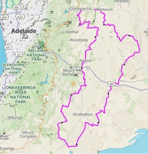
Laratinga Loop – 225 km Adelaide Hills & Fleurieu Adventure Ride 

Distance: Approximately 225 km

 Suggested duration: 5–6 hours including stops and lunch

 Start/Finish: Laratinga / Mount Barker area

 Lunch: Finniss General Store Heritage Café

 Ride style: Adventure / back-road touring

 Suitable for: Adventure bikes, dual-sports and confident road riders

 Terrain: A mixture of winding country roads, back roads and changing elevations


The Laratinga Loop is a cracking 225 km ride that combines some of the best riding country south and east of Adelaide into one very manageable day. 

Rather than simply chasing the quickest route from one destination to another, this loop is all about the journey. It winds its way through the Adelaide Hills, drops down towards the Fleurieu, takes you into Finniss for lunch and then works its way back north and east before eventually returning to the Mount Barker area. 

The result is a route with plenty of variety, constantly changing scenery and enough twists and turns to keep things interesting for the entire day.

The Route

Starting near Laratinga on the eastern side of Mount Barker, the ride initially explores the country east and south of the Mount Barker area. The opening stages are classic Adelaide Hills riding. Expect rolling farmland, tree-lined roads, changing elevations and plenty of corners. The route avoids simply blasting down the main highways wherever possible and instead makes the journey itself the attraction. The GPX shows just how much the elevation changes during the day. The route ranges from less than 20 metres above sea level to approximately 548 metres, so riders experience everything from higher Adelaide Hills country to the flatter country around the lower Fleurieu. The route eventually works its way through the Nairne area before turning south. From here the landscape begins to change as the ride heads deeper into the Hills. The route passes through or very close to Macclesfield, one of those Adelaide Hills towns that seems almost purpose-built for a motorcycle ride. The roads around here are a great mixture of flowing bends, tighter corners and open sections through farmland.

Continuing south, the route passes through the beautiful countryside around Ashbourne before dropping towards the lower Fleurieu.

By now you’ve travelled roughly 90–100 km, making this a particularly enjoyable first half of the ride. There’s enough distance behind you to feel as though you’ve been somewhere, but the day is really only getting started.

Finniss – The Perfect Halfway Stop

At approximately the halfway point comes one of the highlights of the route — Finniss.

It’s a small South Australian country town with plenty of character and, importantly for hungry motorcyclists, an excellent place to stop.Lunch – Finniss General Store Heritage Café Our suggested lunch stop.

Sometimes a lunch stop simply happens to be somewhere convenient along a route. This one is good enough to be considered a destination in its own right. The historic General Store, also known locally as the Old Post Office, has been restored and today operates as a café, general store and fodder shop. The building and its surroundings give it exactly the sort of old-fashioned country atmosphere that suits a day spent exploring South Australia’s back roads. The café is open seven days a week, making it particularly useful when planning a weekend or midweek ride. Current published hours vary slightly by day, with extended evening opening on Friday and Saturday. Most importantly, the coffee is excellent and there’s a genuinely good selection of quality food rather than the limited pies-and-chips menu you sometimes encounter at a country stop. Expect proper café meals, burgers, fish and chips, salads, wraps and other hearty favourites, with an emphasis on produce from the Fleurieu Peninsula and surrounding South Australian producers. There’s indoor and outdoor seating, so it’s an easy place for a group of riders to settle in, get the helmets off and spend an hour talking about everything that’s happened during the first half of the ride. It’s exactly what we look for in a Gravel Hound lunch stop: good coffee, good food, plenty of character and far enough from home to feel like you’ve earned it.

The Run Home

Leaving Finniss with approximately half of the 225 km loop still ahead, the character of the ride changes again. Rather than simply retracing the morning’s route, the GPX heads east and then begins its long sweep north. The country becomes more open as the route works its way towards the Strathalbyn, Langhorne Creek district, with the elevation dropping to some of the lowest points of the entire ride. It’s a nice contrast to the tighter Hills riding earlier in the day. There are longer sight lines, broad agricultural landscapes and that distinctly South Australian combination of open farmland and distant hills. From here the route gradually begins climbing again as it turns north. At around the 155–160 km mark you’re back into more undulating country around Callington, after which the loop continues north-east before beginning its final swing back towards Mount Barker. 

This is one of the things that makes the Laratinga Loop interesting: the second half isn’t simply a return journey. 

Even after lunch there is still a substantial ride ahead. The route reaches some of its highest elevations during the latter stages, climbing back above 500 metres before eventually descending towards the Mount Barker district and the finish.

What Makes This Ride Special?

At 225 km, the Laratinga Loop hits a sweet spot for a social adventure ride. 

It’s long enough to make a proper day of it without becoming an endurance exercise. Add a coffee stop, a decent lunch at Finniss and perhaps another quick stop during the afternoon and you’ve got an easy five or six hours out on the bikes. It’s also a route where the scenery rarely stays the same for very long. Over the course of the loop you’ll experience the higher country of the Adelaide Hills, established Hills towns, heavily treed sections, rolling farmland, the lower country approaching the Fleurieu and the wide-open agricultural landscapes east of the ranges. 

Then you climb all the way back into the Hills again. For adventure-bike riders in particular, that’s a great combination. You don’t need to travel hundreds of kilometres north into the Flinders Ranges to have an enjoyable day exploring South Australia. There are some fantastic roads sitting virtually on Adelaide’s doorstep. 

Gravel Hound Rating

The Laratinga Loop isn’t about conquering some impossibly difficult trail. It’s about something much simpler:  mates, a new route, good roads, changing scenery, good food and 225 kilometres spent exploring somewhere different. For us, that’s exactly what adventure riding should be. Allow yourself most of the day, don’t rush it, stop occasionally to take in the countryside and definitely make time for lunch at Finniss. 

And as always, road and unsealed-road conditions can change considerably with weather, grading and seasonal conditions, so ride to the conditions rather than blindly following the GPX. 225 km. Adelaide Hills. Fleurieu country. A great country café. And a route worth riding again.


Gravel Hound Adventures – Trained by Terrain.


TTG – Swan Reach – Gumeracha

235 km of Adelaide Hills, Murray lands and back-road adventure

There are some rides where the destination matters. Then there are the rides where lunch and the finishing pub matter almost as much as the roads in between. The TTG – Swan Reach – Gumeracha Adventure Route gives you both. Starting around Tea Tree Gully, this approximately 235 km route heads away from suburban Adelaide and into the countryside, eventually taking you east towards Swan Reach and the Murray River before turning back towards the Adelaide Hills and finishing the day at Gumeracha. It makes for a proper day on the bike, with a natural lunch stop roughly halfway through the adventure and an even better place to finish it.

SWAN REACH – LUNCH AT DARK SKY TAKEAWAYBy the time you reach Swan Reach, you'll have earned a decent feed. 

Our suggested lunch stop is Dark Sky Takeaway at Swan Reach. It's perfectly positioned to break the ride into two parts: park the bikes, grab some lunch, have a drink and spend a little time beside the Murray before getting back in the saddle for the return leg. Rather than treating Swan Reach as somewhere to simply ride through, we'd suggest allowing enough time here to enjoy the stop. After all, a Gravel Hound ride isn't a race.

THEN IT'S BACK TOWARDS THE HILLS

Fed and watered, it's time to leave Swan Reach behind and start making your way back towards the Adelaide Hills. The landscape gradually changes again as the route leaves the Murray lands behind and works its way towards Gumeracha. It's one of the things we particularly enjoy about this ride. Over the course of roughly 235 km you experience noticeably different South Australian landscapes without ever having to venture particularly far from Adelaide. And there's a reward waiting at the other end.

FINISH THE DAY AT THE GUMERACHA HOTEL Rather than simply navigating back to the starting point, we've given this ride a proper destination.  The Gumeracha Hotel makes an ideal place to finish the day's adventure. Park the bikes, get the helmets off and sit down for a cold drink while everyone starts retelling exactly what happened during the ride — normally with each version becoming slightly more dramatic than the last. For us, that's part of adventure riding. 

The tracks and roads are important, but so are the stops, the characters, the conversations and the places you discover along the way.

ROUTE INFORMATION

Distance: Approx. 235 km

 Start: Tea Tree Gully area

 Lunch: Dark Sky Takeaway, Swan Reach

 Finish: Gumeracha Hotel

 Area: Adelaide Hills & Murray lands, South Australia

 Route type: Adventure / mixed-surface touring

 Navigation: GPX

 Suitable for: Adventure and dual-sport motorcycles

 Allow: Most of the day, This is a route best enjoyed without rushing it.  Give yourself time for photographs, fuel stops, lunch at Swan Reach and, of course, a proper end-of-ride stop at Gumeracha.

WHO IS THIS ROUTE FOR?

The TTG – Swan Reach – Gumeracha route should suit riders looking for a full day's adventure without the need to travel hundreds of kilometres just to reach the interesting stuff. Mid-size adventure bikes are particularly well suited, but smaller dual-sports and larger adventure machines should also be perfectly at home when ridden appropriately for the conditions.

As always, the difficulty of any unsealed road can change considerably depending on recent weather, grading and traffic. 

Take your time, ride to the conditions and enjoy the journey.

We've done the route planning so you can concentrate on the riding. Download the TTG – Swan Reach – Gumeracha GPX, load it onto your preferred compatible navigation device or app, grab a few mates and make a day of it.

Start in the Adelaide Hills.

Ride out to the Murray.

Lunch at Dark Sky Takeaway in Swan Reach.

Then point the bikes back towards the Hills and finish the adventure at Gumeracha Hotel.

That's our idea of a pretty good day on a motorcycle.

Gravel Hound Adventures

Trained by Terrain. 🐾

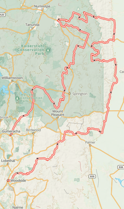
The Barossa Pipeline Run – 212 km of Backroads, Gravel and Barossa Country

There are plenty of quick ways to get to the Barossa.

This isn't one of them.

The Barossa Pipeline Run is a 212 km Gravel Hound adventure route that takes the enjoyable way north, using the Adelaide Hills and South Australian backcountry to turn a visit to Angaston into a proper day's motorcycle ride.

This isn't about punching Angaston into Google Maps and following the quickest blue line. The whole point is the journey: smaller roads, changing scenery, sections of gravel, open farming country and those wonderfully quiet South Australian backroads that make you wonder why everyone else is still sitting on the main highway.

The destination is Angaston, but—as is usually the case with Gravel Hound Adventures—the destination is really just the excuse.

From the Hills to the Barossa

The route begins in familiar Adelaide Hills territory before gradually working its way north.

One of the things I particularly like about rides like this is how quickly the landscape changes.

The greener, tighter country of the Hills gradually gives way to more open farmland. Roads stretch out, visibility improves and eventually the unmistakable landscape of the Barossa begins to appear.

The Barossa is less than an hour from Adelaide if you're in a hurry. South Australia's official tourism information describes it as a region of vineyards, heritage towns and rolling countryside.

But we're adventure riders.

Being in a hurry would rather defeat the purpose.

The Pipeline Run deliberately makes more of the journey, turning what could easily be a straightforward run north into 212 kilometres of exploration.

And that's exactly what a Gravel Hound route should do.

Why “The Pipeline Run”?

Our original working name for this route was simply Angaston Pipeline.

Functional? Yes.

Exciting? Not particularly.

So for the downloadable Gravel Hound route collection we've christened it:

The Barossa Pipeline Run

It tells you where you're heading while retaining a little of the route's original identity.

More importantly, it sounds like somewhere you might actually want to point an adventure bike on Saturday morning.

A Proper Mixed-Surface Day Ride

This isn't intended to be an enduro course.

That's worth making clear.

Gravel Hound Adventures is increasingly about real-world adventure riding: routes you can enjoy on the sort of bikes most of us actually own and ride.

Think CFMOTO 450MT, Tenere 700, Africa Twin, KTM 690, Himalayan, DR-Z400, CRF300 Rally and similar machines.

The Pipeline Run combines sealed country roads with gravel and backroads. The challenge isn't supposed to come from finding the deepest bog hole or the steepest hill we can possibly put on a GPX file.

The reward comes from the route itself.

A good gravel road, an interesting change of scenery, a view you weren't expecting and occasionally having absolutely no idea where the road is taking you are some of the things that make adventure riding enjoyable.

You don't necessarily need 150 horsepower.

You need fuel, a GPX file and preferably someone else to blame when you take the wrong turn.

Angaston – More Than a Turnaround Point

Eventually the route brings you into Angaston, and it's worth allowing enough time to have a look around rather than simply refuelling and disappearing again.


Angaston is one of the Barossa's more attractive historic towns, with broad streets, old buildings, mature trees and the surrounding pastoral and vineyard landscape. The official Barossa Heritage Trail describes it as a rural village where heritage has been integrated into modern life.

There's considerably more here than wine, too.

The town has cafés, restaurants, the Barossa Valley Cheese Company and boutique shops, while the Barossa Farmers Market operates on Saturdays.

For riders wanting to stretch their legs, there's even a 3 km Angaston Heritage Trail starting around the old railway station area.

The railway station itself has an interesting history. The railway finally reached Angaston in 1911, passenger services ceased in 1968, and the restored station precinct is now incorporated into the Barossa Adventure Station.

That's the sort of little bit of history I like finding on a motorcycle ride.

You arrive somewhere for a pie and discover there's actually a story behind the place.

The Important Part – Lunch

Every respectable Gravel Hound route needs a food stop.

It's practically in the rules.

Angaston gives us plenty of choice, so there's no requirement for everyone riding the route to stop at exactly the same place.

Grab a bakery lunch, find a café along Murray Street or simply park the bikes and see what takes your fancy.

And if you've somehow managed to burn enough calories sitting on a motorcycle all morning to justify chocolate, there's now a Melba's Chocolate and Confectionery location in Angaston with coffee, hot chocolates, desserts and savoury options.

I suspect we could probably find an excuse.

For motorcyclists, Angaston works particularly well because it's not merely somewhere to eat. It's a genuine mid-ride destination.

Have something to eat, wander around for twenty minutes, look at the bikes, discuss tyres, complain about fuel prices and eventually remember that you've still got half a ride to complete.

Perfect.

And Then We Head Home – But Not the Same Way

One thing I don't particularly enjoy is spending a morning riding somewhere only to turn around and retrace exactly the same route home.

So we don't.

The Pipeline Run is designed as a loop-style adventure, with the return journey providing another change of scenery and roads.

Psychologically, that makes a big difference to a day's riding.

You're still exploring.

Every junction potentially leads somewhere new and the scenery continues changing rather than becoming a reverse replay of the morning.

By the time you eventually arrive back in familiar territory, you've covered approximately 212 km.

It's enough distance to feel as though you've been somewhere without turning the ride into an endurance event.

What Sort of Rider Is It For?

I'd describe the Barossa Pipeline Run as an adventure-touring day ride rather than a technical trail ride.

You should be comfortable riding an adventure motorcycle on unsealed roads and understand that gravel conditions can change dramatically.

A road that is hard-packed and straightforward in summer can be completely different after several days of rain.

Likewise, corrugations, loose gravel, washouts, fallen branches, roadworks and seasonal closures can appear after we've ridden a route.

That's part of adventure riding.

If you're relatively new to gravel, take your time. Don't feel obliged to ride at somebody else's speed and give yourself plenty of room behind other bikes.

The objective isn't to set a record.

It's to enjoy the ride.

What Bike Do You Need?

Probably the one you've already got.

One of the ideas behind Gravel Hound Adventures is getting away from the notion that you need the newest, biggest or most expensive adventure motorcycle before you can start exploring.

A mid-sized adventure bike would be almost ideal for this route.

My CFMOTO 450MT is exactly the sort of machine I enjoy on rides like this: comfortable enough to cover the distance, manageable on gravel and capable of carrying everything required for a day's riding.

But there's no reason the Pipeline Run couldn't be enjoyed on everything from a DR-Z400 or CRF300 Rally through to a Tenere 700, Africa Twin or one of the bigger adventure machines.

Tyres and rider confidence will probably make more difference than another 50 horsepower.

Make a Day of It

Don't treat the 212 km figure as something that needs to be completed as quickly as possible.

Leave in the morning.

Stop occasionally.

Take photographs.

Have a coffee.

Look at something you've ridden past twenty times without stopping.

Spend some time in Angaston.

That's why these routes exist.

South Australia is remarkably good for this sort of riding. Within a relatively short distance we can move from the Adelaide suburbs into the Hills, through farming country and eventually into one of Australia's best-known wine regions.

You don't need two weeks off work.

Sometimes you just need a free Saturday and a full tank of fuel.

Download the Barossa Pipeline Run GPX

We've now added The Barossa Pipeline Run to the Gravel Hound Adventures downloadable GPX collection.

The download contains the route we've actually explored and ridden—not a route assembled by asking a computer to find a few unsealed roads between two points.

The Barossa Pipeline Run

Distance: approximately 212 km
Region: Adelaide Hills – Barossa – Angaston
Ride type: Adventure touring / mixed surface
Surfaces: Sealed country roads, backroads and gravel
Destination: Angaston
Recommended time: Allow most of the day
GPX Download: AU$4.95

Load the GPX into your compatible motorcycle GPS or navigation application, check the route before departure and then make the ride your own.

A word about route conditions

The GPX represents the route as ridden and recorded. Roads, access, surfaces and conditions can change.

Always obey road closures, private-property signs and official directions. Never follow a GPX track through a closed road simply because the line on your GPS tells you to.

Weather can also dramatically alter unsealed roads, so check local conditions before leaving and ride within your own ability.

The GPX is a route guide, not a guarantee of current road access or conditions.

And please respect the country you're travelling through. In particular, Barossa heritage information asks visitors not to ride or drive amongst vineyards because tyres and footwear can spread pests and diseases. 


Bunyeroo Valley to Alpana

Distance: 62.4km's

Fuel Allowance: 100km's

Terrain: Predominantly on well-formed gravel  tracks

Description: This 62.5 km Flinders Ranges section runs from Bunyeroo Valley north to Alpana, delivering classic outback scenery, winding valley tracks, open gravel sections, creek lines, and big red-range views. The route starts around 503 m elevation, drops to roughly 293 m, then climbs back toward 553 m by the finish, so expect a mix of flowing gravel, dips, climbs, loose corners, and plenty of photo-stop country. It’s a scenic adventure-touring route rather than a hard technical slog,

When to Ride: Avoid in High summer 

What to watch out for: Corrugations, washouts, loose gravel, dry creek crossings, wandering wildlife, and blind crests. Best ridden at a relaxed pace with fuel, water, and tyre pressures sorted before leaving, because once you’re out there, the Flinders has a lovely habit of reminding you who’s really in charge.

Who's it for: This route is best suited to a confident beginner through to intermediate adventure rider.


Woodside - Mannum - Oakbank

Distance: 127km's

Fuel Allowance: Allow 200kms  you can fuel up at Woodside-Mannum  

Ride Time: Approx. 3 hours with Breakfast stop

Terrain: Sealed, unsealed Gravel

Description: A short little flowing ride that blends sweeping gravel, tighter technical climbs, and scenic runs out toward Mannum before returning via a mix of fast open roads and sandy sections. A true adventure touring ride—engaging without being punishing, built for smooth riding, good mates, and big smiles all day.

Rest Stop suggestions: One or two options in Mannum

When to Ride: All year round for this one 

What to watch out for:  Higher elevation sections can be rocky and have deep washouts, intermittent sand sections throughout the ride. Some sections are clay and can be extremely slippery immediately after or during rain. Watch for wildlife, especially on the return through the Hills Surfaces can vary — expect loose gravel in patches After rain, some sections can get slippery

Who's it for: This ride is for intermediate riders who are fairly experienced given the sandy sections and potential for clay.  Technically not too difficult and less experienced riders will probably be fine if they are riding light weight machines.

Craters- Uradla-via Mannum

Distance: 217 km's

Fuel Allowance: Allow 250kms  you can fuel up at Crafers or Mannum

Ride Time: Approx. 4 hours

Terrain: Sealed, unsealed Gravel

Description: This loop is one of those deceptively good South Australian rides — the kind that doesn’t shout about itself, but quietly delivers everything you want from a day in the saddle. Starting out near the Crafers, the ride quickly opens up into a mix of rolling countryside and easy-flowing sections that let you settle into a rhythm. It’s not technical, but it’s engaging enough to keep things interesting — perfect for a relaxed group ride or a solo reset. Heading towards the Murray as you push east, the landscape starts to stretch out and flatten, giving you that classic SA rural feel. The run into Mannum is a highlight — sweeping roads, open views, and that sense you’re heading somewhere worthwhile.

Rest Stop suggestions: One or two options in Mannum ( I generally hit the bakery in the high street)

When to Ride: All year round for this one 

What to watch out for:  Watch for wildlife, especially on the return through the Hills Surfaces can vary — expect loose gravel in patches After rain, some sections can get slippery

Who's it for: This ride is for riders who enjoy a relaxed, scenic loop with a mix of sealed and light gravel roads—perfect for those who want to build confidence off-road while still enjoying a smooth, flowing day in the saddle.

Kanmantoo-Harrogate-Woodside-Callington-Wistow

Distance: 220 km's

Fuel Allowance: Allow 275kms Fuel available at Sterling, best to cover it there or you may be making detours later

Ride Time: 5 -6  Hours

Terrain: Mixed with some long straight sections, can be dusty

Description:  A flowing Adelaide Hills loop linking Kanmantoo, Harrogate, Woodside, Callington, and Wistow through a mix of scenic backroads and easy gravel.

Rest Stop Suggestions: Nairne offers a lot of Cafes and bakeries

Skill level Required: Suitable for beginners and intermediate riders big adventure bike friendly

When to Ride: All year round for this one 

What to watch out for:  Loose gravel patches, changing road surfaces, and wildlife—especially in the tighter, tree-lined sections.

Who this ride is for: Riders looking for a relaxed, confidence-building day out with plenty of variety but nothing overly technical.

Tea Tree Gully to Clare

Distance: 400kms 

Fuel Allowance: Allow 450kms

Ride Time: 7-8 Hours 

Terrain: Sealed, unsealed Gravel, some sandy sections (not deep and not long very sparse)

Description: The Clare Run is one of those rides that delivers a bit of everything without ever feeling rushed. Rolling out from the Hills, it quickly transitions into open country where the roads start to flow and the pace naturally picks up. You’ll move between sealed sections and long stretches of well-formed gravel, with the occasional loose patch or sandy section just to keep you switched on. As you push further north, the landscape opens up into classic wine country—wide views, quiet backroads, and that sense that you’ve properly left the city behind. It’s not a technical ride, but it’s engaging enough to keep things interesting, making it perfect for a full day in the saddle with a well-earned stop in Clare before turning back. One of those rides where the kilometres disappear easily and you finish the day feeling like you’ve actually been somewhere.

Rest stop suggestions: Kapunda bakery for breakfast, Lunch at Pikes Brewery (plenty of food and drink options in Clare)

Skill level required: Suitable for beginners and intermediate riders big adventure bike friendly

Best time to ride: After some light rain can get very dusty if a few bikes are involved 

What to watch out for: Kangaroos can be an issue before mid morning compounded by low sun and poor visibility loose gravel on outside of corners

who's it for: Perfect for riders who want a relaxed but rewarding day out—ideal for newer gravel riders or anyone on a larger adventure bike chasing good scenery without unnecessary drama.

Angaston Loop

Distance: 185kms

Fuel Allowance: Allow 200kms Fuel available at Woodside and Angaston 

Ride Time: 4-5 Hours depending on Stops

Terrain: Sealed, Unsealed Packed Gravel Occasional sand and clay Patch

 Description: The Angaston Loop is one of those rides that sneaks up on you—in the best way. Rolling out through the Adelaide Hills, it quickly settles into a rhythm of fast, flowing gravel, tight country backroads, and the occasional section that reminds you to stay honest. It’s not a brutal ride, but it’s got just enough variety—hardpack, loose patches, and a few technical moments—to keep things interesting. Perfect for a solid day out with the crew, a good coffee stop in Angaston, and just enough challenge to make you feel like you’ve actually ridden, not just travelled.

Rest Stop Suggestion: Angaston Bakery (About halfway)

Skill Level Required: Suitable or beginners and big adventure bikes

Best Time to Ride: Spring and Autumn are ideal. After rain, some clay sections can become slippery.

What to Watch For:

  • Loose gravel on corners (“marbles on concrete”)
  • Clay sections that get slick after rain
  • Occasional sandy patches that can catch newer riders out

Who It’s For:  Perfect for newer riders building confidence on gravel, or anyone on a larger adventure bike looking for a relaxed but engaging day out.

Optional Detour:  Plenty of side tracks in the Barossa region if you feel like extending the ride or adding a bit more challenge.